આ MCQ મોડ્યુલ આના પર આધારિત છે: Landforms and Disasters: Landslides, Avalanches, GLOFs and Dust Storms
Landforms and Disasters: Landslides, Avalanches, GLOFs and Dust Storms
Ch 2 — Shaping of the Earth’s Surface
🌐 ભાષા:
🧠 AI-આધારિત MCQ મૂલ્યાંકન
▲
📝 વર્કશીટ / મૂલ્યાંકન
▲
આ મૂલ્યાંકન આના પર આધારિત હશે: Landforms and Disasters: Landslides, Avalanches, GLOFs and Dust Storms
મૂલ્યાંકન બનાવવામાં તેમની સામગ્રી સામેલ કરવા ચિત્રો, PDF અથવા Word દસ્તાવેજ અપલોડ કરો.
Landforms and disasters
Landforms are linked to several natural disasters. For each one below, the causes are explained, followed by where it strikes, how to reduce the risk, and recent examples.
LET'S EXPLORE — Add to the disaster map
Bloom: L3 Apply
Use newspapers, atlases and books to add more disaster-prone areas from India and the world, more mitigation? measures, and the most recent examples you can find.
✅ Pointers
How to go about it: for each hazard, add (1) one more prone area in India and one abroad, (2) one more mitigation measure, and (3) the most recent example you can find with its month and year. Good sources are newspapers, an atlas and reports from national and state disaster management authorities. Check that each example names a place and a date, so it can be verified.
Landslides
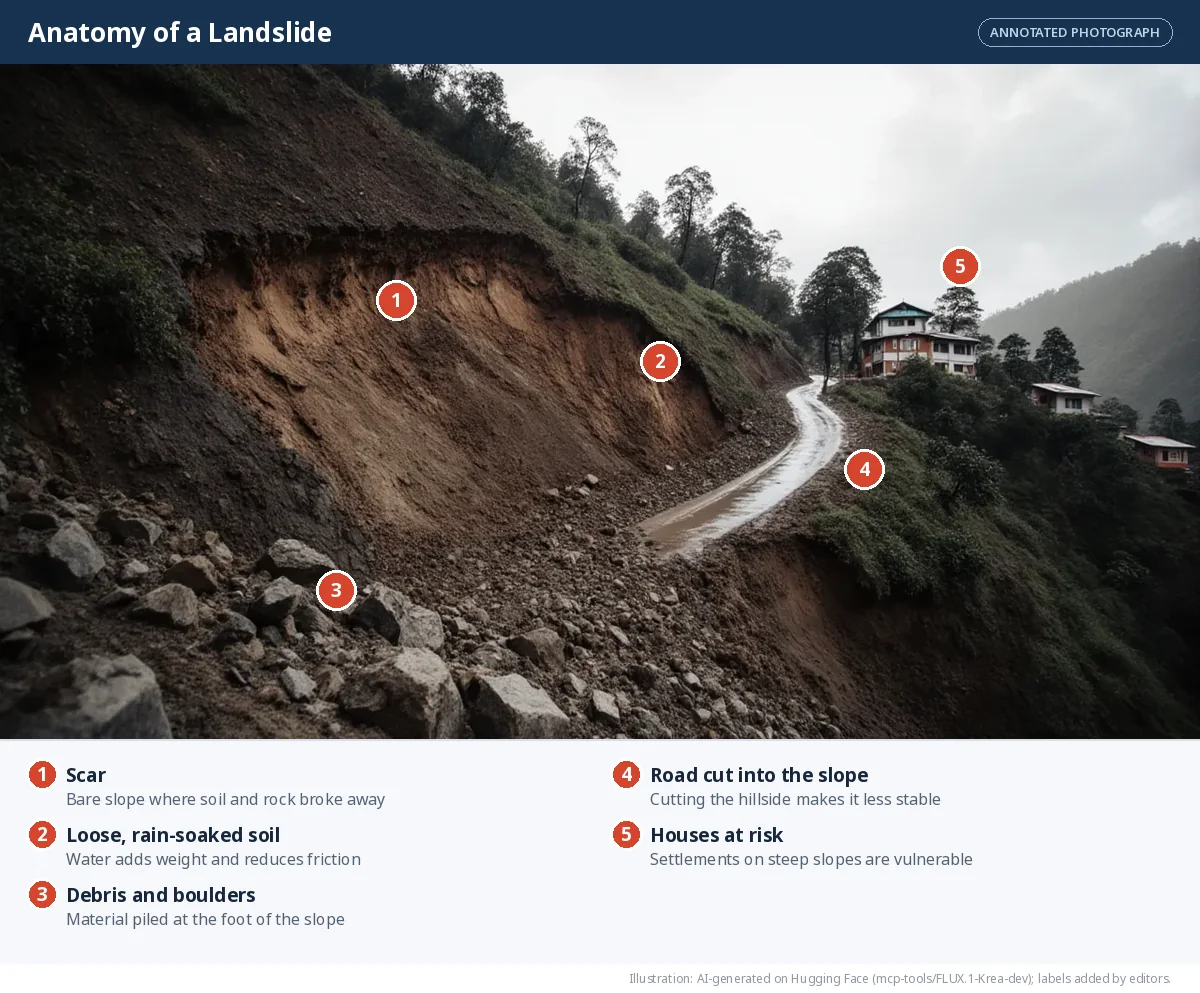
A landslide is the sudden movement of rock, soil and debris down a slope.
Causes - Heavy, continuous rain soaks the soil, adding weight and reducing friction. - Earthquakes and volcanic eruptions shake and weaken slopes. - Steep slopes with loose or weathered rock. - Human activities — deforestation, mining, road-cutting and unplanned construction on hillsides. - Poor drainage and improper land use let water collect until the slope fails.
SIMULATOR — What makes a slope fail?
Change the conditions on the hillside and watch the landslide risk meter respond. Rain runs from 0 (dry) to 100 (days of downpour).
An illustrative model, not a forecast. It shows how the causes listed above add up. Real slope stability depends on rock type, soil depth and drainage.
| Prone areas | India: the Himalaya (Uttarakhand, Himachal Pradesh, Jammu and Kashmir, Sikkim), the North-East, the Western Ghats (Kerala, Karnataka, Maharashtra) and the Nilgiris. World: Nepal, Japan, the Andes, the Alps |
| Mitigation | Plant trees and grass on slopes; build retaining walls and proper drainage; avoid building on steep, unstable slopes; follow landslide hazard maps; set up rain-based early warnings |
| Recent examples | Wayanad, Kerala (July 2024); Irshalwadi, Raigad, Maharashtra (July 2023) |
Avalanches
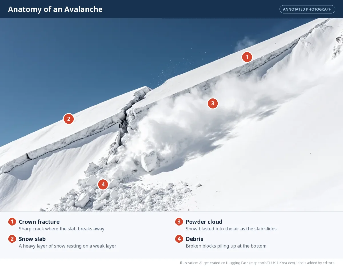
An avalanche is a large mass of snow sliding rapidly down a mountain slope.
Causes - Heavy snowfall in a short time overloads the snowpack?, especially when it rests on a weak layer. - A sudden rise in temperature partly melts the snow and reduces friction. - Strong winds pile up snow unevenly, creating fragile layers. - Triggers — earthquakes, vibrations, and human activities such as skiing, trekking or construction.
| Prone areas | India: Jammu and Kashmir, Ladakh, Himachal Pradesh, Uttarakhand, Sikkim and Arunachal Pradesh. World: the Alps, the Rockies, the Nepal Himalaya |
| Mitigation | Avalanche forecasts and warnings; snow fences and barriers; tree cover on slopes; controlled release of dangerous snow; closing risky routes after heavy snowfall |
| Recent examples | Draupadi ka Danda-II peak, Uttarakhand (October 2022); near Nathu La, Sikkim (April 2023) |
Glacial Lake Outburst Floods (GLOFs)
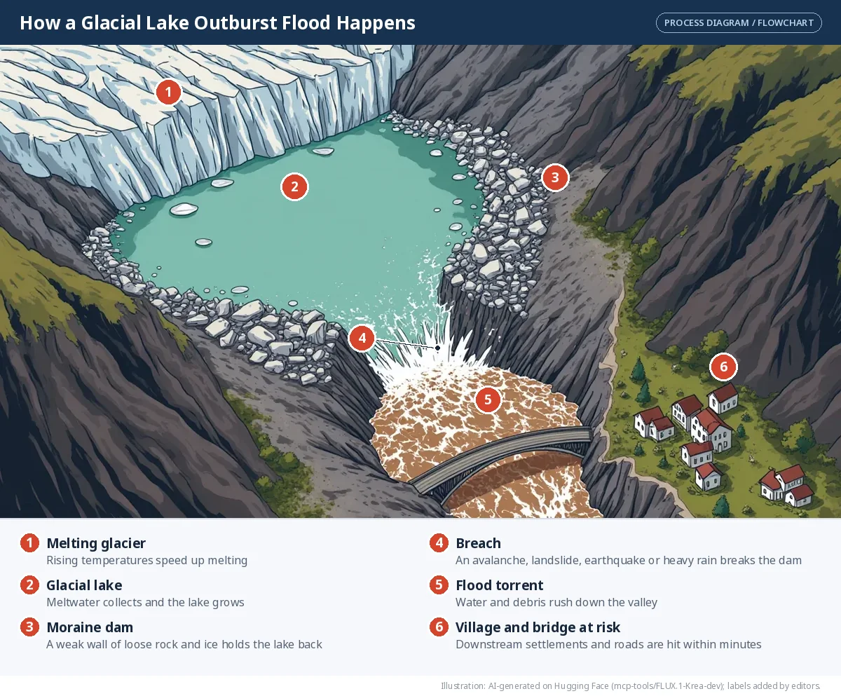
A GLOF is the sudden release of a huge volume of water from a lake formed by a melting glacier.
Causes - Rising temperatures melt glaciers faster, so glacial lakes grow and press harder on their natural dams of ice or loose moraine?. - Heavy rain or snowfall adds extra water. - Earthquakes, avalanches or landslides can strike the lake or weaken the dam. - When the dam fails, the water rushes out and floods the valleys below.
SIMULATOR — A glacial lake and its dam
Melting fills the lake. See when the natural dam is in danger.
Dam limit
Illustrative only. Real lakes are monitored with satellites and sensors; the aim here is to see why warming, extra water and a trigger together are dangerous.
| Prone areas | India: Sikkim, Uttarakhand, Himachal Pradesh, Ladakh, Arunachal Pradesh. World: Nepal, Bhutan, the Andes of Peru |
| Mitigation | Map and monitor glacial lakes with satellites; install early warning systems; safely lower lake levels; keep settlements and projects out of flood paths |
| Recent examples | South Lhonak Lake, Sikkim (October 2023); Chorabari Lake at Kedarnath, Uttarakhand (June 2013) |
Dust storms
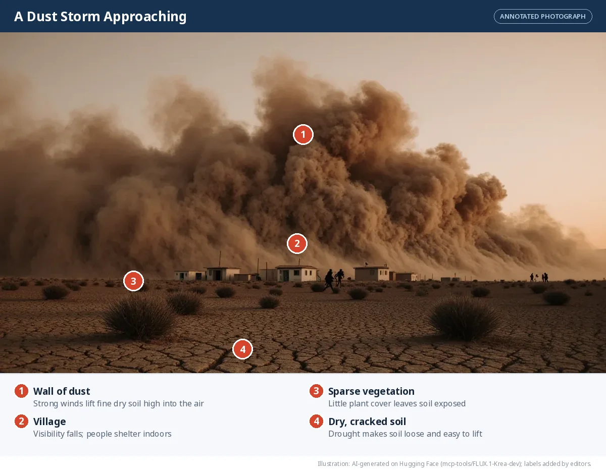
A dust storm is a strong wind that lifts huge amounts of loose, dry soil and sand into the air.
Causes - Drought and low rainfall dry out the soil so the wind can lift it. - Dry and semi-arid regions have loose, bare soil. - Sparse vegetation — from deforestation, overgrazing or poor farming — leaves land exposed. - Climate change and extreme weather can make storms more frequent and stronger.
| Prone areas | India: Rajasthan, Punjab, Haryana, Delhi, western Uttar Pradesh. World: the Sahara, the Arabian Peninsula, the Gobi, central Australia |
| Mitigation | Plant shelterbelts (rows of trees) as windbreaks; fix sand dunes with vegetation; control overgrazing; keep soil covered; follow weather warnings |
| Recent examples | Rajasthan and Uttar Pradesh (May 2018), which killed more than 100 people |
Recent Events at a Glance
Jun 2013
Chorabari Lake, Kedarnath, Uttarakhand: glacial lake outburst flood.
May 2018
Dust storms in Rajasthan and Uttar Pradesh killed more than 100 people.
Feb 2021
Chamoli district, Uttarakhand: a rock and ice avalanche triggered a sudden, devastating flood.
Oct 2022
Draupadi ka Danda-II peak, Uttarakhand: avalanche.
Apr 2023
Near Nathu La, Sikkim: avalanche.
Jul 2023
Irshalwadi, Raigad, Maharashtra: landslide.
Oct 2023
South Lhonak Lake, Sikkim: glacial lake outburst flood.
Jul 2024
Wayanad, Kerala: landslide.
Before we move on
- The Earth has three main layers — crust, mantle and core. The crust and rigid upper mantle form the lithosphere, which is broken into tectonic plates that move over the soft asthenosphere.
- Convection currents in the mantle move the plates. At convergent, divergent and transform boundaries, plate movement builds mountains, makes new crust, and causes earthquakes and volcanoes.
- Internal forces (earthquakes, volcanoes, folding and faulting) build up the crust; external forces (weathering, erosion and deposition) wear it down and reshape it.
- The agents of gradation — running water, waves, glaciers, wind and underground water — carve and build landforms that shape how people live, farm, travel and settle.
- Landslides, avalanches, GLOFs and dust storms are disasters linked to particular landforms; understanding them helps us prepare and reduce risk.
🎯 Match the mitigation to the hazard
Each measure protects against one hazard best. Which one?
Retaining walls, proper drainage and landslide hazard maps
Snow fences and barriers; controlled release of dangerous snow
Satellite mapping of lakes, early warning systems, safely lowering lake levels
Planting shelterbelts and fixing sand dunes with vegetation
Controlling overgrazing and keeping soil covered
📝 Competency-Based Questions — Landforms and Disasters
A hill town in Himachal Pradesh has had three days of continuous heavy rain. Last year a new road was cut into the steep slope above the market, and many trees on that slope were cleared for houses. On the fourth morning a section of the hillside slides onto the road, blocking it and cutting off two villages.
Q1. A landslide is the:
L1 RememberAnswer: (b) — A landslide is the sudden movement of rock, soil and debris down a slope.
Q2. Identify two causes that combined to trigger the landslide in this town.
L2 UnderstandModel Answer: Any two: heavy, continuous rain soaked the soil, adding weight and reducing friction; the steep slope; deforestation on the slope; road-cutting and construction on the hillside; poor drainage.
Q3. Suggest two measures the town could take to reduce the risk in future.
L3 ApplyModel Answer: Plant trees and grass on the slope; build retaining walls and proper drainage; avoid new building on steep, unstable slopes; follow landslide hazard maps; set up rain-based early warnings.
Q4. Compare an avalanche with this landslide in terms of what moves and what typically triggers it.
L4 AnalyseModel Answer: In a landslide, rock, soil and debris move, typically triggered by heavy rain, earthquakes or human activity such as road-cutting. In an avalanche, a mass of snow moves, typically triggered by heavy snowfall on a weak layer, a sudden rise in temperature, wind or vibrations. Both are gravity-driven slope failures on steep ground.
Q5. A councillor says, "Nothing can be done about natural disasters, so mitigation is a waste of money." Evaluate this view.
L5 EvaluateModel Answer: The view is weak. The natural event itself cannot be stopped, but the harm depends on human choices: where people build, whether slopes are planted and drained, and whether warnings exist. Mitigation such as planting, retaining walls, hazard maps and early warnings reduces deaths and damage, and is usually far cheaper than repairing a disaster.
⚖️ Assertion–Reason Questions — Landforms and Disasters
Options:
(A) Both A and R are true, and R is the correct explanation of A.
(B) Both A and R are true, but R is NOT the correct explanation of A.
(C) A is true, but R is false.
(D) A is false, but R is true.
(A) Both A and R are true, and R is the correct explanation of A.
(B) Both A and R are true, but R is NOT the correct explanation of A.
(C) A is true, but R is false.
(D) A is false, but R is true.
Assertion (A): Clearing trees from a hillside increases the risk of landslides.
Reason (R): Roots bind the soil together, and slopes without vegetation are less stable.
Answer: (A) — Both true and R explains A. That is why planting trees and grass is a main mitigation measure.
Assertion (A): The risk of glacial lake outburst floods is increasing in the Himalaya.
Reason (R): Rising temperatures melt glaciers faster, so glacial lakes grow and press harder on their natural dams.
Answer: (A) — Both true and R explains A. A trigger such as an avalanche, landslide or earthquake can then break the dam.
Assertion (A): Dust storms are most common in humid, densely forested regions.
Reason (R): Dust storms need dry, loose soil and sparse vegetation.
Answer: (D) — A is false, R is true. Dust storms occur in dry and semi-arid regions such as Rajasthan and the Sahara.
Frequently Asked Questions
What are the causes of landslides?
Heavy continuous rain, earthquakes and volcanic eruptions, steep slopes with loose or weathered rock, deforestation, mining, road-cutting and unplanned construction, and poor drainage.
What causes avalanches?
Heavy snowfall in a short time overloading the snowpack, a sudden rise in temperature, strong winds piling snow unevenly, and triggers such as earthquakes, vibrations, skiing, trekking or construction.
What is a GLOF?
A Glacial Lake Outburst Flood: a sudden release of a huge volume of water from a lake formed by a melting glacier when its natural dam of ice or moraine fails.
Which parts of India are prone to dust storms?
Rajasthan, Punjab, Haryana, Delhi and western Uttar Pradesh. In May 2018 dust storms in Rajasthan and Uttar Pradesh killed more than 100 people.
How can the risk from these landform-related disasters be reduced?
Plant trees and shelterbelts, build retaining walls and drainage, follow hazard maps, monitor glacial lakes and snowpack, set up early warnings and keep settlements out of danger paths.
Illustrations: AI-generated on Hugging Face and labelled by our editors. Charts and maps are drawn from cited data. Notes follow the NCERT textbook Understanding Society: India and Beyond — Grade 9, Part 1 (NCERT).
AI ટ્યુટર
Landforms and Disasters: Landslides, Avalanches, GLOFs and Dust Storms
તૈયાર
🎁 Join our community and get free AI credits!