આ MCQ મોડ્યુલ આના પર આધારિત છે: Weathering, Erosion and the Agents of Gradation
Weathering, Erosion and the Agents of Gradation
Ch 2 — Shaping of the Earth’s Surface
🌐 ભાષા:
🧠 AI-આધારિત MCQ મૂલ્યાંકન
▲
📝 વર્કશીટ / મૂલ્યાંકન
▲
આ મૂલ્યાંકન આના પર આધારિત હશે: Weathering, Erosion and the Agents of Gradation
મૂલ્યાંકન બનાવવામાં તેમની સામગ્રી સામેલ કરવા ચિત્રો, PDF અથવા Word દસ્તાવેજ અપલોડ કરો.
Weathering and erosion
Internal forces build up the land; external forces wear it down. Over very long periods, weathering and erosion wear down mountains, carve valleys, build plains and create caves, cliffs and deltas.
Weathering
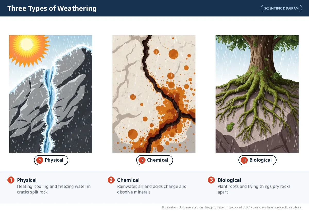
Weathering is the breaking down of rocks at or near the surface. Nothing moves — the rock simply breaks or changes where it is. There are three types:
| Type | What happens | Example |
|---|---|---|
| Physical | Rocks break into smaller pieces without changing their minerals | Desert rocks heat by day and cool at night until they crack; water freezes in cracks, expands and splits the rock |
| Chemical | Minerals react with water, air or acids and change into new substances | Rainwater slowly dissolves limestone; iron in rocks rusts |
| Biological | Living things break rock | Plant roots grow into cracks and pry rocks apart; burrowing animals loosen rock |
Weathering is the first step in making soil.
Erosion
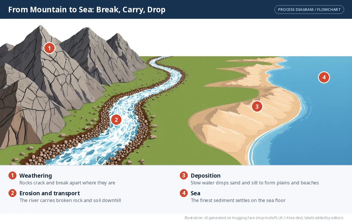
Erosion is the wearing away of soil and rock and carrying it somewhere else by water, wind, ice or waves. This movement is the key difference from weathering.
- Water erosion — by rivers, rain and runoff
- Wind erosion — common in dry, sandy areas
- Glacial erosion — moving ice scrapes and carries rock
- Coastal erosion — waves wear away the shore
What erosion removes has to go somewhere. When the moving water, wind or ice slows down, it drops its load: this is deposition?.
🎯 Break, carry or drop?
Weathering breaks rock in place, erosion carries it away, deposition drops it. Which is happening?
Tree roots grow into a crack and split a boulder in two.
A river carries fertile topsoil from a hillside to the plains downstream.
A river slows as it enters the sea and leaves its sediment as a delta.
Rainwater slowly dissolves limestone.
Wind blows sand across a desert and piles it into a dune.
Desert rocks heat by day and cool at night until they crack.
How erosion affects people
- Farmers lose fertile topsoil, so crop yields fall.
- People living near rivers and coasts can lose land, houses and roads.
- Construction and mining become riskier on unstable ground.
- Tourism and fishing suffer when beaches, rivers and fertile land are destroyed.
Let's explore
Look at pictures of land eroded by water and by wind. How is a farmer on a hillslope affected by water erosion? How is a farmer in a dry region affected by wind erosion?
Don't miss out — India's long tradition of soil and water conservation
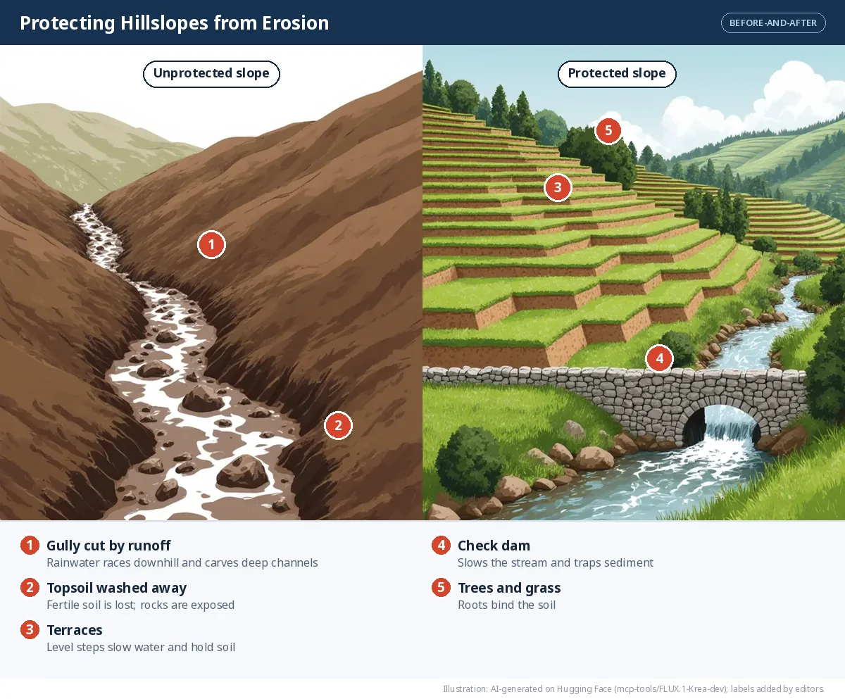
People in the Sindhu-Sarasvatī Civilisation used contouring?, bunding, terracing, dams and canals to manage water. Texts such as the Vedas, the Kṛiṣhiparāśhara, Kauṭilya's Arthaśhāstra and the Vṛikṣhāyurveda describe such practices; the Arthaśhāstra even classifies land by its fertility.
- Contouring — digging trenches along the contour lines of a hillside to slow, hold and soak in rainwater.
- Bunding — building earthen embankments along contours to slow runoff and keep soil moist.
- Terracing — cutting a slope into level steps so water cannot rush downhill.
- Check dams — small barriers across streams that slow water, trap sediment and recharge groundwater.
- The Zabo system of Nagaland combines forest, farming and animal rearing, using earthen bunds on hillslopes to conserve soil and water.
Agents of gradation
Agents of gradation? are the natural forces that wear down, carry and deposit material, slowly levelling the Earth's surface — lowering high land and filling in low land.
| Agent | Main erosional work | Main depositional work |
|---|---|---|
| Running water | V-shaped valleys, waterfalls | Floodplains, levees, deltas |
| Glaciers | U-shaped valleys, cirques, aretes | Moraines |
| Wind | Yardangs, mushroom rocks, deflation hollows | Sand dunes |
| Sea waves | Cliffs, caves, arches, stacks | Beaches, sand bars |
| Groundwater | Caves, sinkholes | Stalactites, stalagmites |
🌟 Don't miss out — landforms shaped history
Fertile river plains — the Ganga, Brahmaputra, Indus and Nile — fed farming communities and early cities. The Himalaya protected India from invasions, yet passes such as the Khyber Pass let people, goods and ideas through. The Thar Desert discouraged large settlements but was crossed by caravan routes linked to the Silk Route. Harbours on the coasts connected kingdoms in south India with distant lands. Wars, settlements, trade and culture have always been shaped by the land.
Running water
Erosional landforms: V-shaped valleys, waterfalls, rapids.
Depositional landforms: floodplains, levees, meanders and oxbow lakes, deltas, alluvial fans.
Why it matters to people: fertile plains such as those of the Ganga and Nile fed early cities; deltas grow rice and jute; waterfalls bring tourism and hydroelectricity.
Glaciers
Erosional landforms: cirques, aretes, U-shaped valleys, hanging valleys, fjords.
Depositional landforms: lateral, medial and terminal moraines.
Why it matters to people: glaciers are sources of fresh water for great rivers; U-shaped valleys and cirques attract trekkers; fjords make sheltered harbours.
Wind
Erosional landforms: yardangs, mushroom rocks, ventifacts, deflation hollows, desert pavements.
Depositional landforms: dunes: barchan, longitudinal (seif), transverse, star and parabolic.
Why it matters to people: oases support settlements and trade; dunes act as natural barriers and draw tourists.
Sea waves
Erosional landforms: sea cliffs, wave-cut platforms, sea caves, sea arches, sea stacks.
Depositional landforms: beaches and sand bars.
Why it matters to people: beaches support tourism and fishing and protect coastal settlements; eroding coasts may need protection.
Underground water
Erosional landforms: caves, sinkholes (dolines), underground rivers.
Depositional landforms: stalactites, stalagmites, pillars (columns).
Why it matters to people: caves and underground rivers provide fresh water and tourism; some caves have religious significance.
Running water
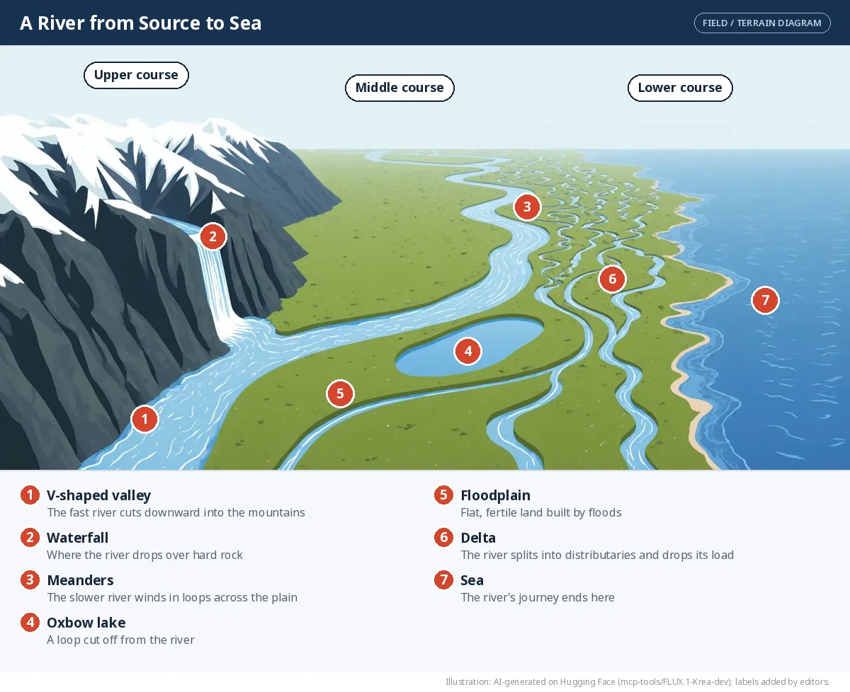
Rivers shape the land through erosion, transportation and deposition along their course.
| Course | Slope and energy | Main work | Landforms |
|---|---|---|---|
| Upper (mountains) | Steep, fast, powerful | Erosion (cutting down) | V-shaped valleys, waterfalls, rapids |
| Middle (plains) | Gentler, slower | Erosion on bends and deposition | Meanders, oxbow lakes, floodplains |
| Lower (near the sea) | Very gentle, slow | Deposition | Deltas, levees, alluvial fans |
SIMULATOR — A river from source to sea
Slide along the river. Watch how its slope, energy and work change, and which landforms you meet.
The profile is drawn in a simplified way: steep at the source, gentler in the middle and almost level near the sea.
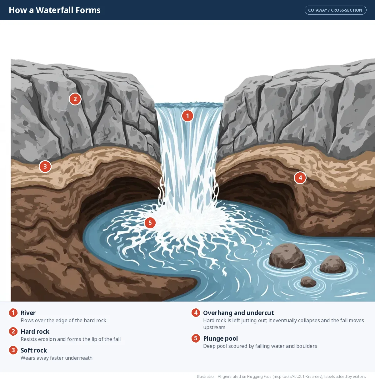
Waterfall. A waterfall forms in the upper course where a river flows over a band of hard rock lying above softer rock. The soft rock wears away faster, leaving a steep drop and a deep plunge pool at the bottom. Waterfalls attract tourists, can generate hydroelectricity, offer trekking and photography, and are often culturally or religiously important.
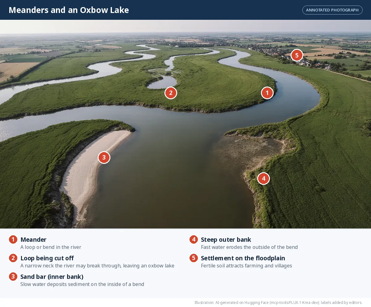
Meander and oxbow lake. In the middle and lower course, a river winds in loops called meanders?. It erodes the outer bank of each bend, where water flows fastest, and deposits sediment on the inner bank, where it is slow. Loops grow wider until the river cuts across the narrow neck of a loop during a flood, leaving the old loop behind as a crescent-shaped oxbow lake. The fertile soil around meanders supports farming and villages, and meandering rivers are used for navigation and irrigation. The Grand Anicut (Kallanai) on the Kaveri in Tamil Nadu, built nearly 2,000 years ago, still diverts river water for irrigation.
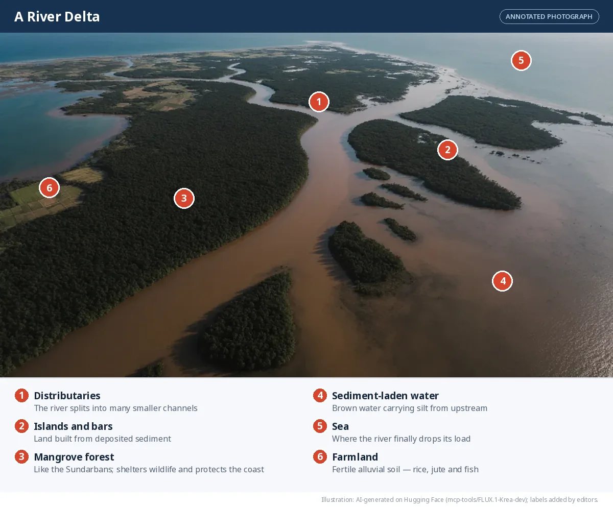
Delta?. Where a river enters a sea, ocean or lake, it slows down and drops its sediment. Over time this builds a fan-shaped or triangular area of land — a delta — crossed by many branching channels called distributaries. Deltas have very fertile alluvial soil, ideal for rice and jute; the mix of fresh and salt water supports rich fisheries; and rivers provide transport routes. But deltas are low-lying and prone to floods and cyclones.
Let's explore
The Sundarbans lies in the delta of the Ganga and Brahmaputra — the largest delta in the world — and is the largest mangrove forest on Earth. Find out what makes it unique and why tourists visit it.
Waves and currents
Waves and currents constantly reshape coastlines. (You will learn more about them in Part 2 of this textbook.)
Deposition by waves creates beaches of sand, pebbles or shells. Beaches support tourism, fishing and local livelihoods, and they act as natural barriers that protect coastal settlements from strong waves.
Erosion by waves creates:
- Sea cliffs — steep rock faces where waves undercut the base of the coast
- Wave-cut platforms — flat rocky areas left behind as cliffs retreat
- Sea caves — hollows where waves attack weak rock
- Sea arches — formed when caves on opposite sides of a headland meet
- Sea stacks — pillars of rock left standing when an arch collapses
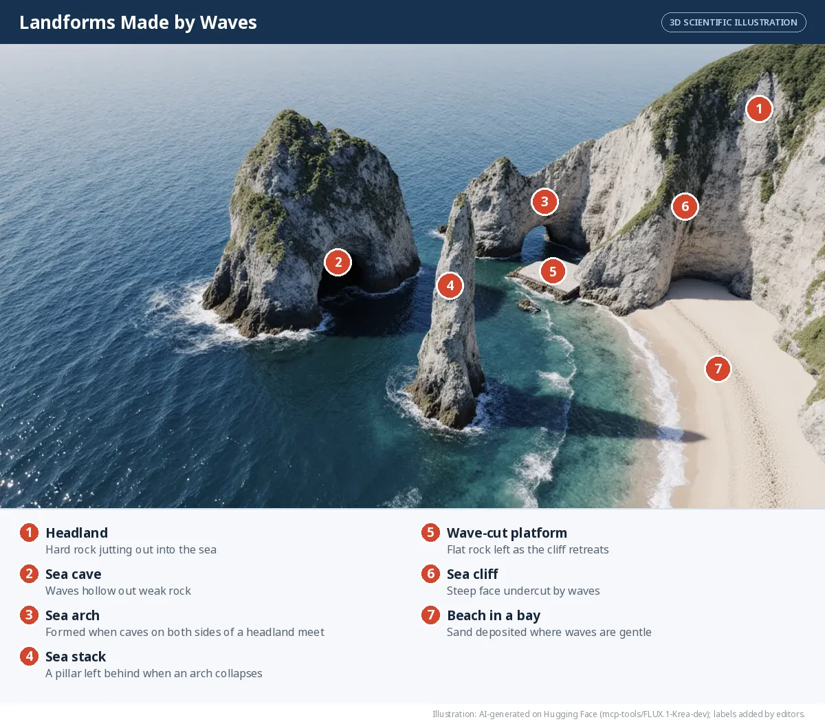
Some of these places are valuable for tourism; others need coastal protection to keep settlements safe.
Glaciers
A glacier is a huge mass of ice that moves slowly downhill, scraping and carrying rock as it goes.
Landforms of glacial erosion - Cirque — a bowl-shaped hollow at the head of a glacier?, often holding a small lake - Arete — a sharp, knife-edged ridge between two cirques or valleys - U-shaped valley — a river valley widened and deepened by ice - Hanging valley — a smaller side valley left high above the main valley, often with a waterfall - Fjord — a deep, narrow sea inlet formed when the sea floods a glacial valley
Landforms of glacial deposition — moraines?. The rock, soil and debris a glacier carries is called till. When the ice melts, till is left behind as moraines: - Lateral moraines along the sides of a glacier - Medial moraines down the middle, where two glaciers join - Terminal moraines at the glacier's snout, marking its furthest advance
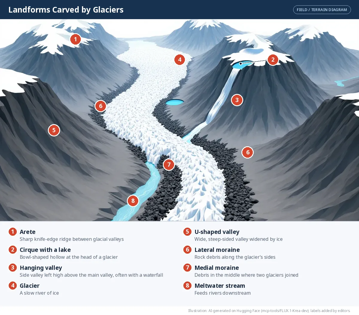
Glacial landforms matter to people: U-shaped valleys and cirques draw trekkers, skiers and mountaineers; fjords make sheltered harbours; glacial soil can be fertile; moraines can dam lakes used for water supply and hydroelectric power. Above all, glaciers are sources of fresh water, feeding rivers such as the Ganga and Indus that sustain hundreds of millions of people downstream.
THINK ABOUT IT — The Chamoli flood, February 2021
Bloom: L4 Analyse
In February 2021, a sudden, devastating flood struck the Chamoli district of Uttarakhand. Many people and animals died, and buildings, roads, bridges and hydroelectric projects were badly damaged, cutting off villages. Find out what caused this sudden flood.
✅ Pointers
What scientists found: the flood was traced to a massive rock and ice avalanche that broke off a steep mountainside in the Ronti Gad valley. It turned into a fast-moving debris flow down the Rishiganga and Dhauliganga rivers. Rising temperatures and weakened, fractured rock are thought to have contributed. You will meet this kind of event again in the next part: landslides, avalanches and glacial lake outburst floods.
Wind
In deserts and dry regions, wind is the main agent of erosion. It picks up loose sand and dust, carries it and sand-blasts rocks.
Landforms of wind erosion - Yardangs — long, streamlined rock ridges carved in the direction of the wind - Mushroom rocks — rocks worn narrow at the base, where wind-blown sand is heaviest - Ventifacts — stones polished and faceted by sand-blasting - Deflation hollows (blowouts) — shallow depressions where wind has removed loose material; if they reach groundwater, an oasis forms - Desert pavements — flat surfaces of pebbles left behind after fine particles are blown away
Landforms of wind deposition — dunes - Barchan dunes — crescent-shaped, with horns pointing downwind; form where sand is limited and wind blows from one direction - Longitudinal (seif) dunes — long ridges parallel to the wind - Transverse dunes — ridges at right angles to the wind, where sand is plentiful - Star dunes — with several arms, where winds blow from many directions - Parabolic dunes — U-shaped, often held in place by plants
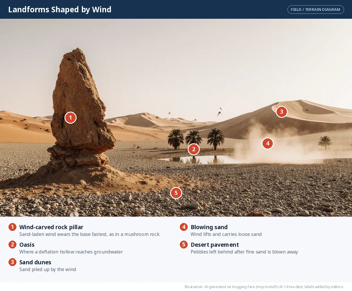
Wind landforms influence where people settle and farm in dry regions. Oases support settlements and trade; dunes can act as natural barriers, protect coasts from strong winds, and offer tourism and adventure sports; dune sand is sometimes used in construction. Unique desert landforms also attract tourists and scientists.
Underground water
Rainwater absorbs carbon dioxide and becomes a weak acid. As it seeps through limestone, it slowly dissolves the rock. The landscape this creates is called karst topography?.
- Caves — hollow spaces dissolved out of the rock
- Stalactites — icicle-shaped deposits hanging from cave ceilings
- Stalagmites — deposits rising from cave floors
- Pillars (columns) — where a stalactite and stalagmite meet
- Sinkholes (dolines) — hollows formed when the ground collapses into a cavity below
- Underground rivers — streams flowing through cave systems
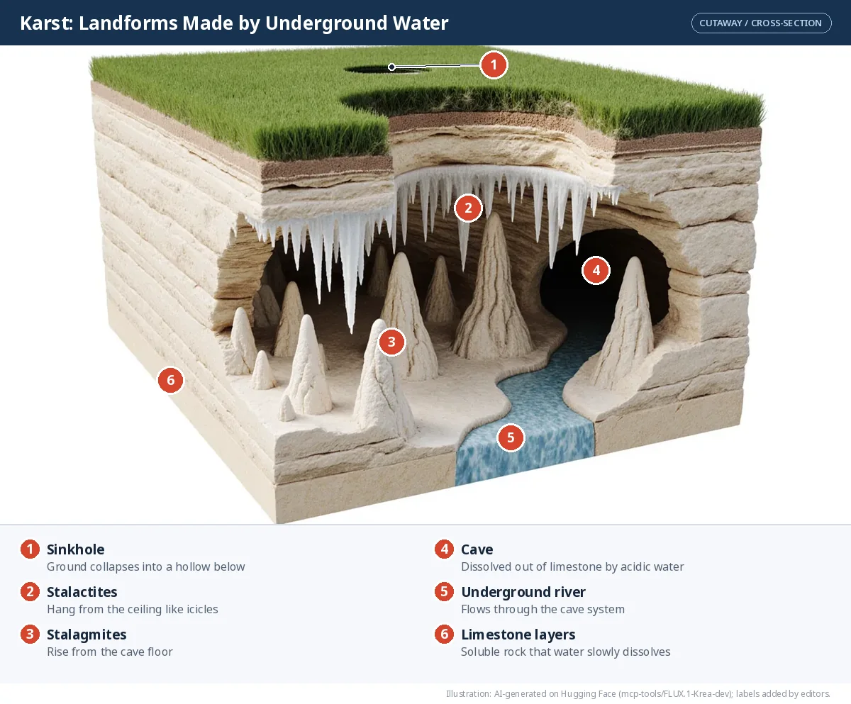
Caves and underground rivers provide fresh water and tourism, and some caves — such as Borra Caves in Andhra Pradesh and the Mawsmai Cave in Meghalaya — are famous attractions; others have religious significance.
Let's explore
Observe the landforms around your school or home. Which agent — running water, wind, ice, waves or groundwater — do you think shaped them?
🎯 Name the landform
Each description matches one landform. Choose the right one.
A crescent-shaped lake left behind when a river cuts across the neck of a loop.
A bowl-shaped hollow at the head of a glacier, often holding a small lake.
A pillar of rock left standing in the sea after an arch collapses.
A crescent-shaped sand dune with its horns pointing downwind.
An icicle-shaped deposit hanging from a cave ceiling.
A fan- or triangle-shaped area of land at a river mouth, with many branching channels.
📝 Competency-Based Questions — Landforms and Their Agents
Asha's family farms a steep hillside in Nagaland. After a heavy monsoon, the bare upper slope has deep gullies, while the fields lower down are covered with a fresh layer of silt. Her grandfather uses earthen bunds and terraces, as in the traditional Zabo system, on the part he has protected. In the valley below, a river winds in wide loops before it reaches the plains.
Q1. The wearing away of soil from the bare upper slope and its removal by running water is called:
L1 RememberAnswer: (b) — Erosion is the wearing away and carrying away of soil and rock. The silt on the lower fields is then deposited when the water slows.
Q2. Why does the part of the hillside with bunds and terraces lose less soil?
L2 UnderstandModel Answer: Bunds and terraces slow the runoff, so water soaks into the soil instead of rushing downhill and carrying it away. Cutting the slope into level steps stops the water from gaining speed.
Q3. Which landforms would you expect along the loops of the river in the valley, and how does the river form them?
L3 ApplyModel Answer: Meanders, and possibly oxbow lakes and floodplains. The river erodes the outer bank of each bend (where water flows fastest) and deposits sediment on the inner bank (where it is slow). During a flood it may cut across a loop, leaving an oxbow lake.
Q4. Compare how deforestation on the upper slope and terracing on the lower slope would affect farmers over ten years.
L4 AnalyseModel Answer: Deforestation exposes topsoil to rain and wind, so gullies form, fertile soil is lost and yields fall; silt may also choke streams. Terracing holds soil and water, protecting yields. Over ten years the terraced fields stay productive while the bare slope degrades.
Q5. A neighbour says that traditional practices like contouring and check dams are outdated. Evaluate this view.
L5 EvaluateModel Answer: The view is weak. Such practices have been used since the Sindhu-Sarasvatī Civilisation and are described in texts like the Arthaśhāstra; they are cheap, use local materials and still work. Modern methods can be combined with them, for example planting trees on bunds.
⚖️ Assertion–Reason Questions — Weathering, Erosion, Gradation
Options:
(A) Both A and R are true, and R is the correct explanation of A.
(B) Both A and R are true, but R is NOT the correct explanation of A.
(C) A is true, but R is false.
(D) A is false, but R is true.
(A) Both A and R are true, and R is the correct explanation of A.
(B) Both A and R are true, but R is NOT the correct explanation of A.
(C) A is true, but R is false.
(D) A is false, but R is true.
Assertion (A): Weathering does not involve the movement of material.
Reason (R): In weathering rocks simply break or change where they are, while erosion carries the material away.
Answer: (A) — Both true and R explains A. That is the key difference between weathering and erosion.
Assertion (A): Deltas are good for growing rice and jute.
Reason (R): Deltas have very fertile alluvial soil deposited by rivers.
Answer: (A) — Both true and R explains A. But deltas are low-lying and prone to floods and cyclones.
Assertion (A): A waterfall forms where a river flows over a band of hard rock lying above softer rock.
Reason (R): The softer rock below wears away faster, undercutting the hard rock and leaving a steep drop.
Answer: (A) — Both true and R explains A. A plunge pool is scoured at the base, and the overhang eventually collapses, so the fall slowly moves upstream.
Frequently Asked Questions
What is the difference between weathering and erosion?
Weathering breaks rocks down where they are, without moving them. Erosion wears away rock and soil and carries it elsewhere by water, wind, ice or waves.
What are the agents of gradation?
Running water, glaciers, wind, sea waves and groundwater. They wear down, carry and deposit material, levelling the Earth's surface.
How is an oxbow lake formed?
A river erodes the outer bank of a meander and deposits sediment on the inner bank until the loop is almost closed. During a flood the river cuts across the narrow neck, leaving the old loop as a crescent-shaped lake.
How does a waterfall form?
Where a river flows over a band of hard rock lying above softer rock, the soft rock wears away faster. This leaves a steep drop and a deep plunge pool at the bottom.
How can soil erosion be reduced?
By planting trees and grass, contouring, bunding, terracing, building check dams, avoiding overgrazing and keeping fields covered.
Illustrations: AI-generated on Hugging Face and labelled by our editors. Charts and maps are drawn from cited data. Notes follow the NCERT textbook Understanding Society: India and Beyond — Grade 9, Part 1 (NCERT).
AI ટ્યુટર
Weathering, Erosion and the Agents of Gradation
તૈયાર
🎁 Join our community and get free AI credits!