આ MCQ મોડ્યુલ આના પર આધારિત છે: Inside the Earth and Plate Tectonics
Inside the Earth and Plate Tectonics
Ch 2 — Shaping of the Earth’s Surface
🌐 ભાષા:
🧠 AI-આધારિત MCQ મૂલ્યાંકન
▲
📝 વર્કશીટ / મૂલ્યાંકન
▲
આ મૂલ્યાંકન આના પર આધારિત હશે: Inside the Earth and Plate Tectonics
મૂલ્યાંકન બનાવવામાં તેમની સામગ્રી સામેલ કરવા ચિત્રો, PDF અથવા Word દસ્તાવેજ અપલોડ કરો.
🎯 Big questions
- What shapes the Earth's surface?
- What is plate tectonics?, and what happens when plates move?
- How are landforms formed, and how can we classify them?
- How are people and other living beings connected to landforms?
- How do disasters linked to landforms affect human lives?
The ground beneath your feet feels still, but the Earth's surface is always changing. Two sets of forces are at work:
- Internal (endogenic) forces act from inside the Earth. They lift mountains, open ocean basins, shake the ground in earthquakes and push up volcanoes.
- External (exogenic) forces act on the surface. Sun, water, ice, wind and waves slowly wear the land down and rebuild it elsewhere.
The idea that ties the internal forces together is plate tectonics. Understanding it explains where mountains, volcanoes, earthquakes, continents and oceans are found — and why.
Inside the Earth
The Earth is built in layers, a little like an onion.
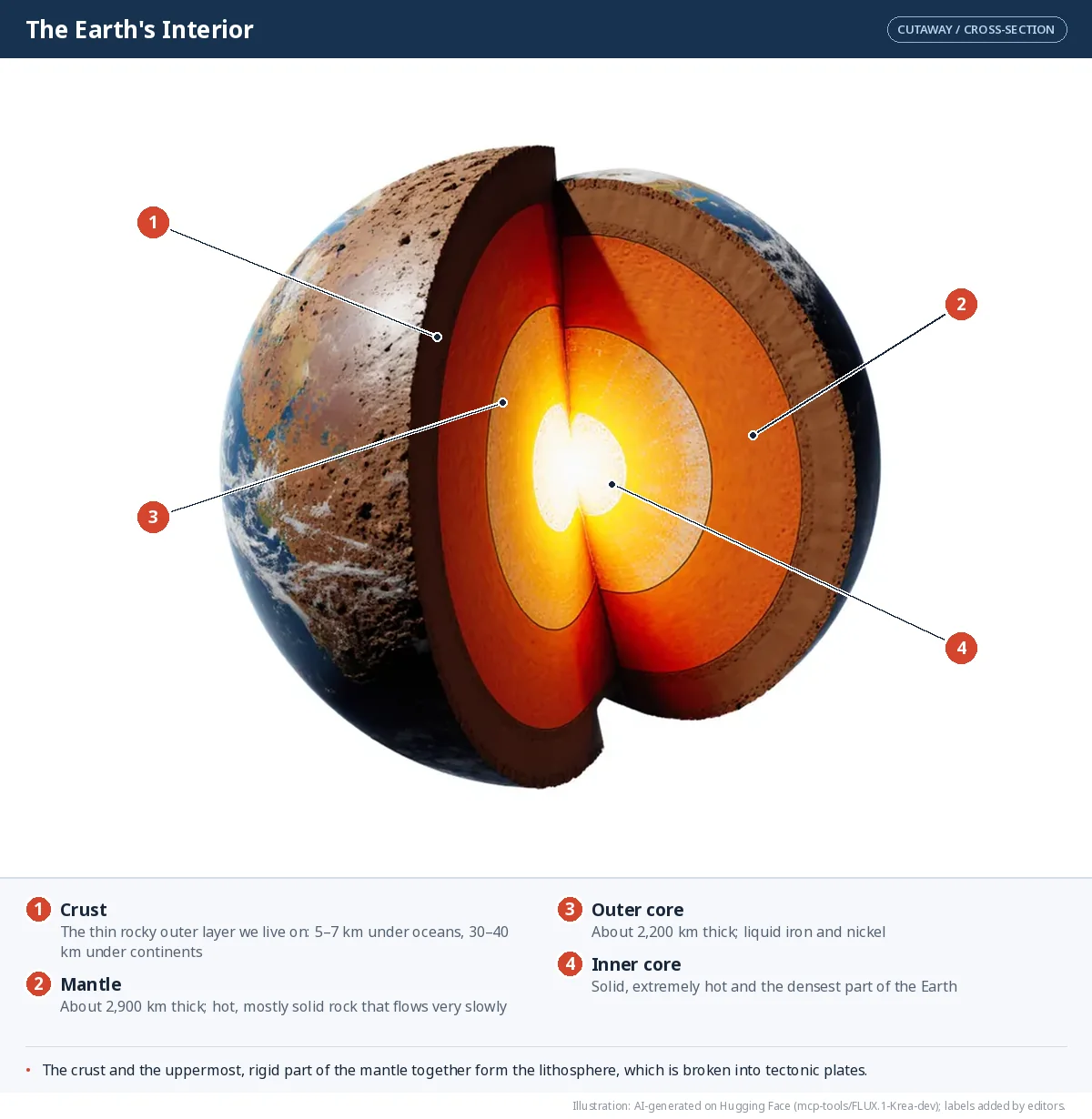
| Layer | Approximate thickness | What it is like |
|---|---|---|
| Crust | 5–7 km under oceans; 30–40 km under continents | The thin, rocky outer skin on which we live |
| Mantle | about 2,900 km | Very hot, mostly solid rock that can flow extremely slowly |
| Outer core | about 2,200 km | Liquid, mainly iron and nickel |
| Inner core | about 1,250 km (to the centre) | Solid, extremely hot, the densest part of the Earth |
The distance from the surface to the centre is roughly 6,375 km. Look at how thin the crust is when everything is drawn to the same scale:
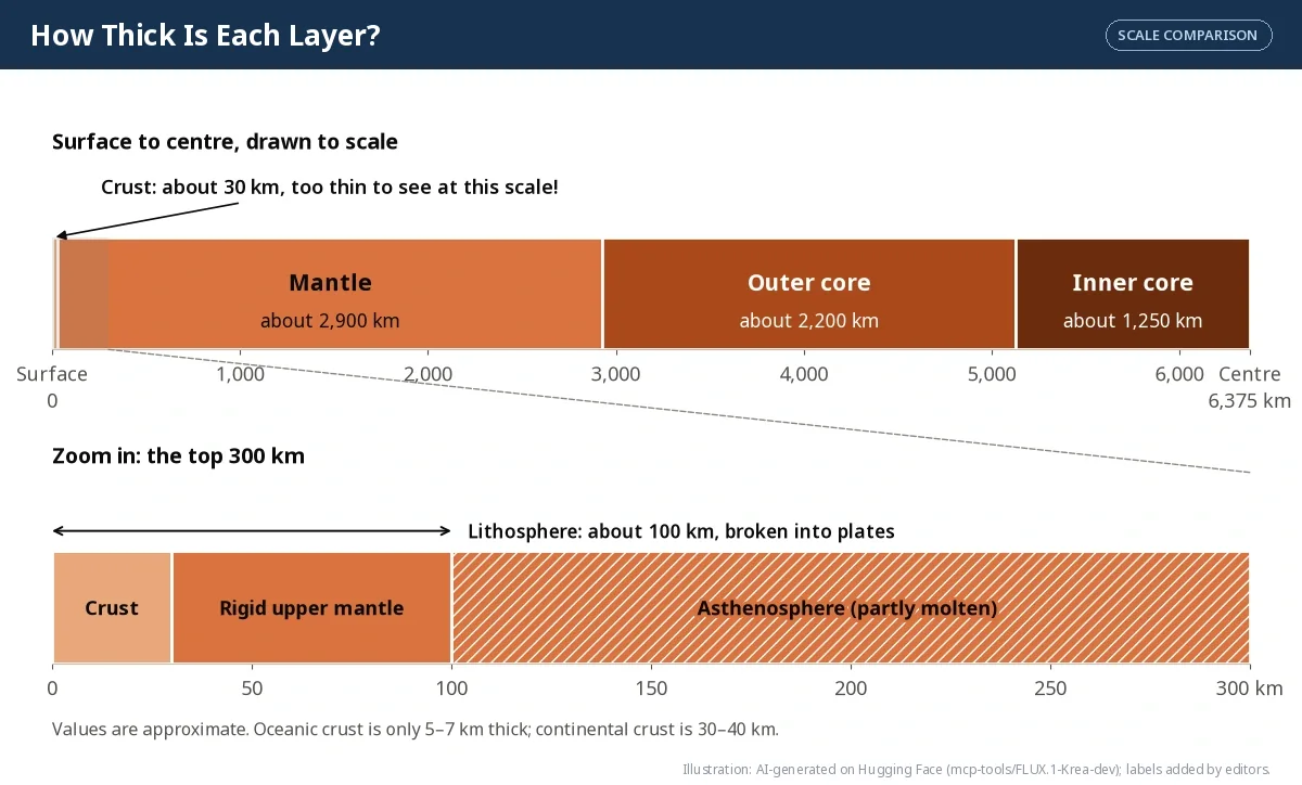
How thick is each layer? (kilometres, log scale)
Values from the table above; the crust is shown at about 35 km, the thickness under continents. A log scale is used so the very thin crust is still visible next to the 2,900 km mantle.
Two more names matter for plate tectonics:
- Lithosphere? — the crust plus the rigid top part of the mantle, about 100 km thick. This is the layer that is broken into plates.
- Asthenosphere? — the hot, soft, partly molten layer just below the lithosphere. Because it can flow, the plates above it can move.
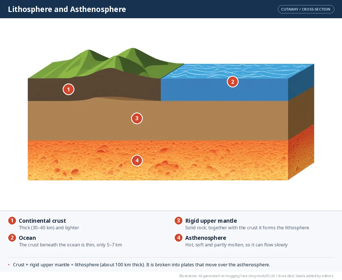
Plate tectonics
Plate tectonics is the theory — put forward by the geophysicist W.J. Morgan and others in the 1960s — that the Earth's outer shell is not one solid piece. It is broken into large and small slabs called tectonic plates, which slowly move over the asthenosphere and create mountains, earthquakes and volcanoes.
Plates move only a few centimetres a year — about as fast as your fingernails grow. There are three kinds:
- Continental plates carry continents.
- Oceanic plates carry ocean floors.
- Mixed plates carry both.
The seven major plates are the Pacific, Eurasian, African, North American, South American, Indo-Australian and Antarctic plates. Smaller ones include the Nazca, Arabian, Philippine, Caribbean and Cocos plates.
What makes plates move?
Heat. The core heats the mantle from below. Hot rock rises slowly, spreads out beneath the lithosphere, cools and sinks again. This endless loop is a convection current?, just like the circulation in a pot of water on a stove. As the mantle circulates, it drags, pushes and pulls the plates above it.
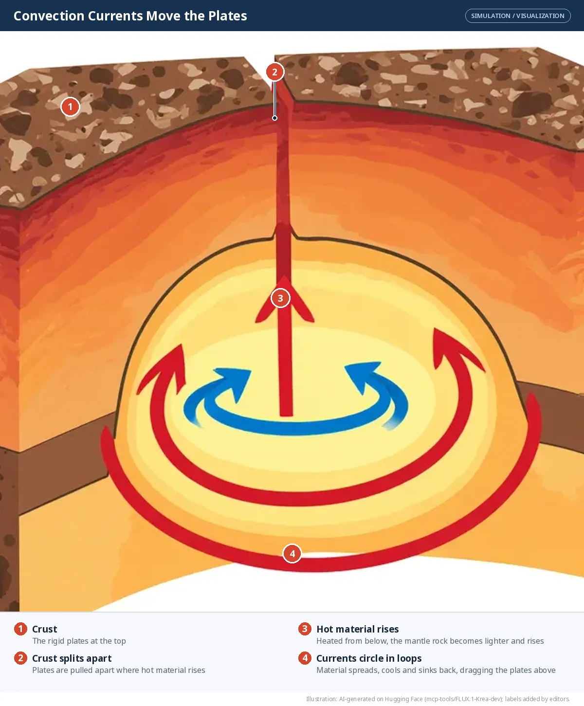
Heat travels outward in three ways: conduction (through solid rock), convection (by moving rock) and advection (carried by rising magma?). Every layer adds to the heat that flows out of the Earth:
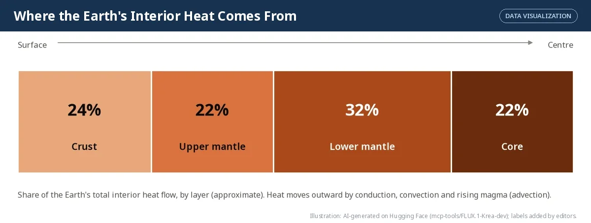
Where does the Earth's interior heat flow come from? (share by layer, %)
Figure 2.5 as data. Hover or tap a slice to read its value.
SIMULATOR — How far can a plate travel?
Plates move only a few centimetres a year, but they have an enormous amount of time. Set a speed and a time and see the distance.
Rule of thumb: 1 cm per year for 1 million years = 10 km. Real speeds change over time; the Indian Plate moved much faster before it collided with Eurasia.
Plate boundaries
Where plates meet are plate boundaries. What happens there depends on how the plates move.
| Boundary | Plate movement | What it creates | Example |
|---|---|---|---|
| Convergent (continent–continent) | Towards each other | Fold mountains | Himalaya (Indian and Eurasian plates) |
| Convergent (ocean–continent) | Towards each other; oceanic plate sinks | Ocean trenches, volcanoes, earthquakes | Andes, west coast of South America |
| Divergent | Away from each other | New crust, mid-ocean ridges, rift valleys | Mid-Atlantic Ridge |
| Transform | Slide past each other | Earthquakes (no crust made or destroyed) | San Andreas Fault, USA |
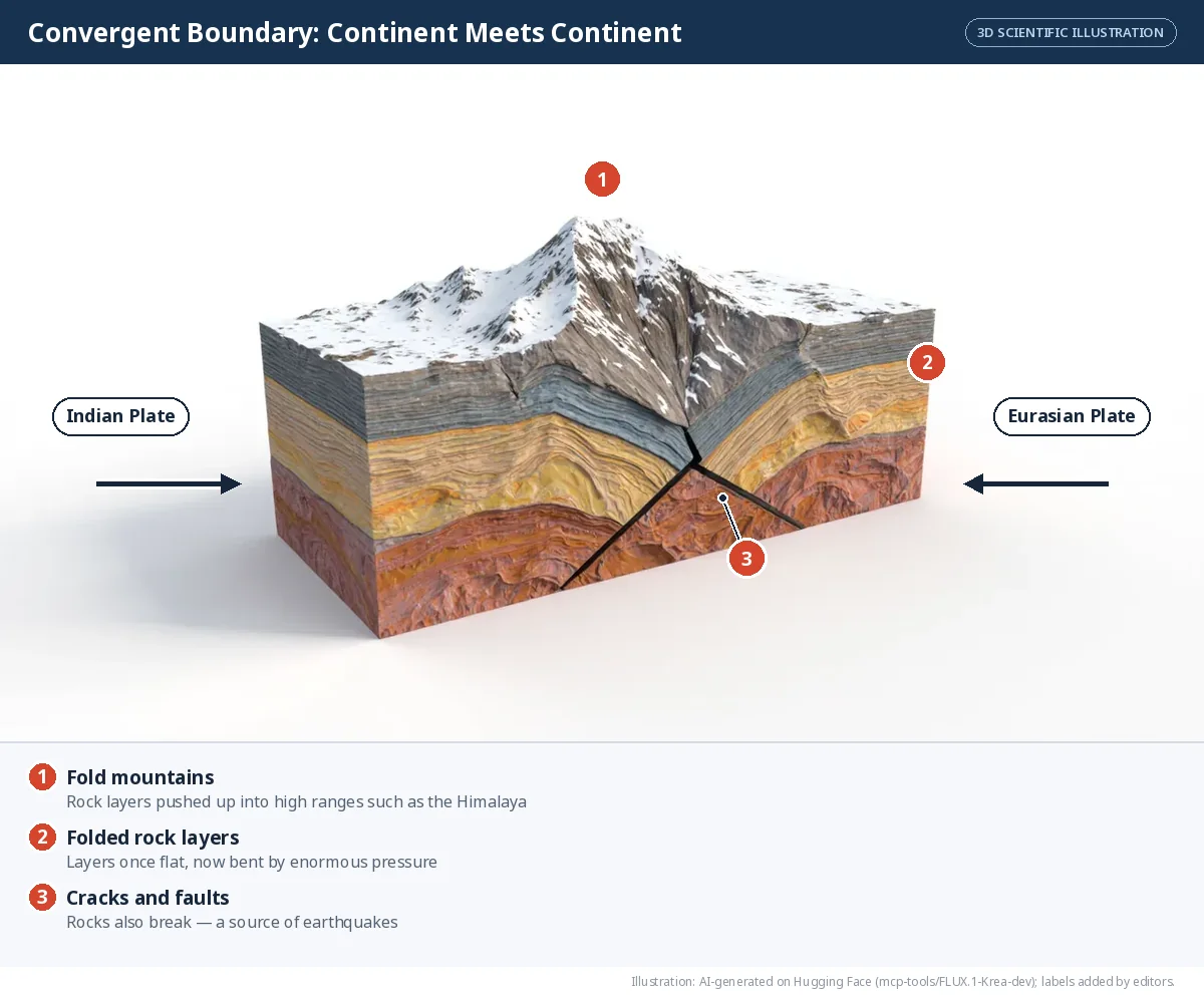
Convergent boundaries. When two continental plates collide, neither sinks easily, so the crust crumples and folds upward. The Indian Plate has been pushing into the Eurasian Plate for about 50 million years, and it is still raising the Himalaya.
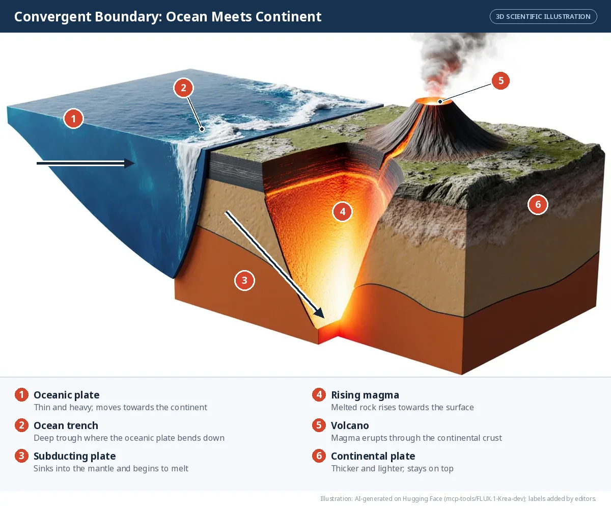
When an oceanic plate meets a continental plate, the heavier oceanic plate sinks beneath the lighter continental plate. This sinking is called subduction?. The sinking plate melts, and the magma rises to form volcanoes, while the grinding plates cause earthquakes.
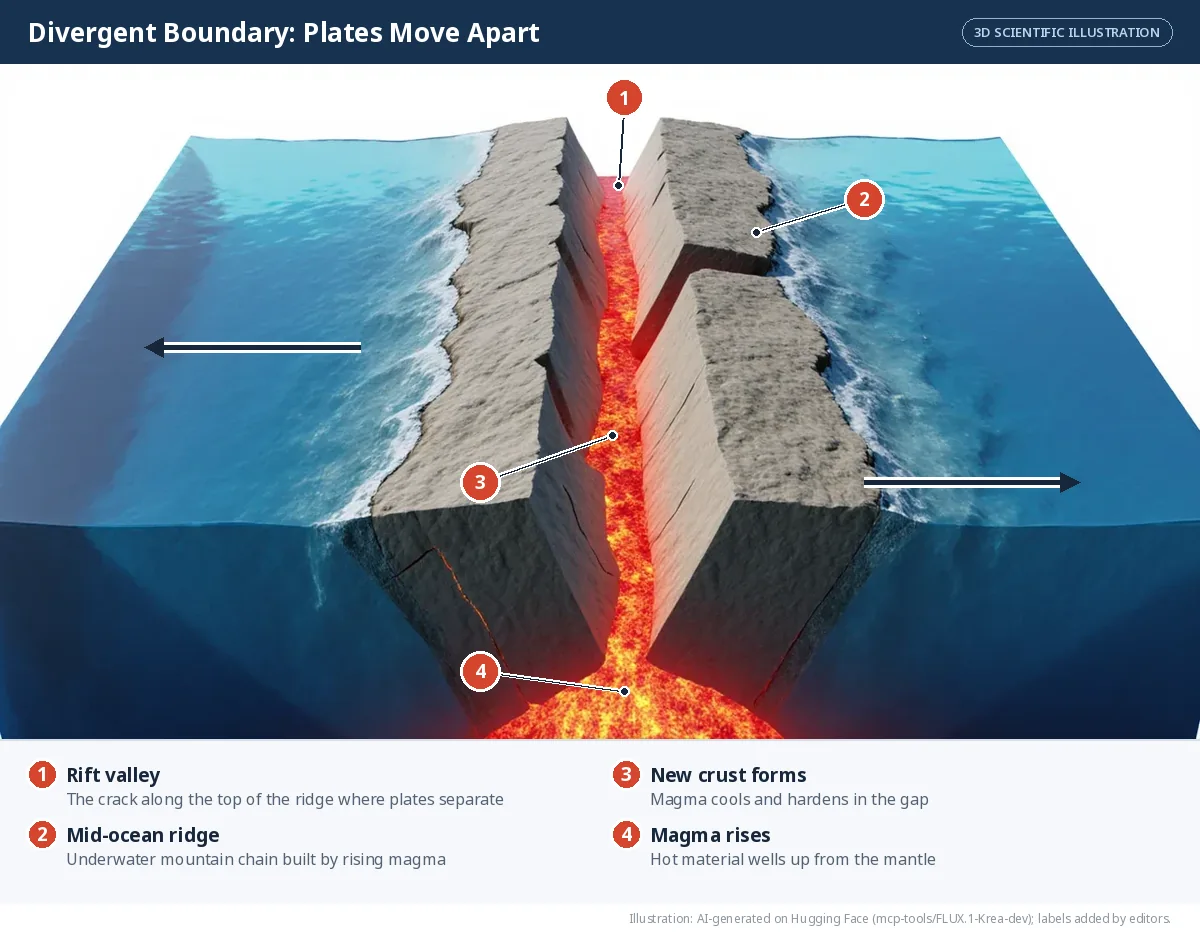
Divergent boundaries. Where plates pull apart, magma rises to fill the gap and cools into new crust. On the ocean floor this builds long underwater mountain chains called mid-ocean ridges?.
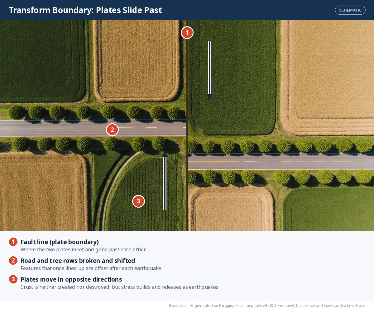
Transform boundaries. Here plates scrape sideways past each other. Stress builds up until the rocks suddenly slip — an earthquake.
SIMULATOR — Plate Boundary Explorer
Choose a boundary, press play and watch what the plates create. Change the speed to fast-forward millions of years.
A simplified model: real plates are hundreds of kilometres wide and the changes take millions of years. The animation compresses 10 million years into one run.
Plate tectonics shapes the surface
Plate movement explains the formation of mountains, valleys, ocean basins, volcanoes and earthquakes — and even why the continents and oceans are where they are. Most earthquakes and volcanoes happen along plate boundaries, especially around the Pacific Ocean, a horseshoe-shaped belt known as the Ring of Fire?.
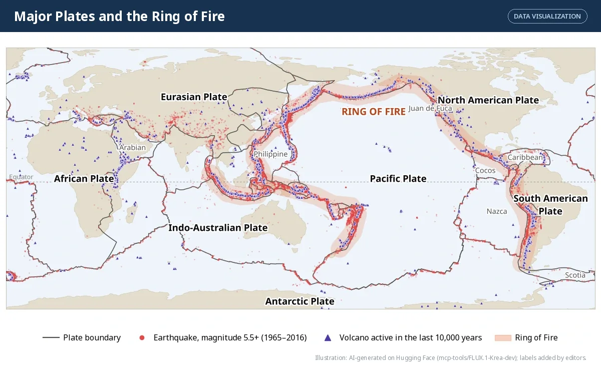
LET'S MAP — Plates, boundaries and patterns
- Pick any two plates on Figure 2.10 and complete the table in your notebook:
| Name of the plate | Continents it carries | Oceans it carries |
|---|---|---|
- Compare the plate boundaries with the earthquake dots and volcano triangles. What pattern do you see?
- Using an atlas or a globe, list the countries that lie on the Ring of Fire.
Knowing where plates meet helps us map earthquake- and volcano-prone regions and plan for disasters.
LET'S EXPLORE — Does India face earthquake risk?
Bloom: L3 Apply
Yes. The Indian Plate is still pushing north into the Eurasian Plate, so the Himalaya and the North-East are among the most earthquake-prone regions in the world. Earthquakes also strike elsewhere: the Bhuj earthquake in Gujarat (26 January 2001) killed about 20,000 people. In a densely populated country, poorly built houses, crowded towns and unsafe construction on slopes turn earthquakes into disasters. Find your own district on India's seismic zone map. Which zone is it in?
Don't miss out — bhūkampa
Ancient Indians called an earthquake bhūkampa, "the shaking of the Earth". In the Bṛihatsaṁhitā, the scholar Varāhamihira devoted a section to earthquakes. He recorded signs he believed came before them — changes in wind, rain, clouds and animal behaviour — and linked quakes to four elemental forces: Vāyu (wind), Agni (fire), Indra (thunder) and Varuṇa (water). It was an early attempt to combine careful observation with reasoning about natural events.
✅ Pointers
Why the risk is high: the Indian Plate is still moving north at a few centimetres a year and pushing into the Eurasian Plate, so stress keeps building along the Himalaya and the North-East. Why it becomes a disaster: earthquakes kill people mostly through collapsing buildings, so weak construction, crowded towns and building on unstable slopes matter as much as the shaking itself (Bhuj, 2001). Your district: look it up on the seismic zone map issued by the Bureau of Indian Standards (a higher zone means higher risk) and note what the zone tells builders to do.
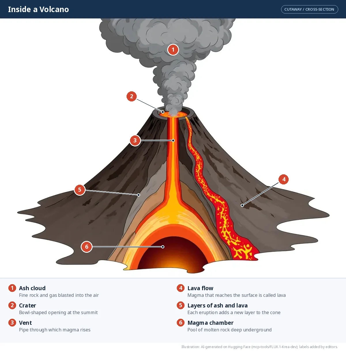
Volcanoes. A volcano is an opening in the crust through which molten rock (magma), gases and ash escape. Once magma reaches the surface it is called lava. Volcanic ash can blanket fields and towns in grey powder — clear evidence of the powerful forces inside the Earth.
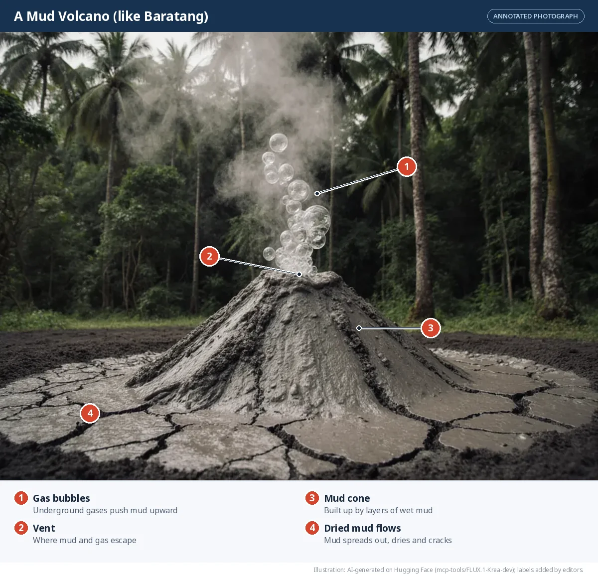
🌟 Don't miss out — India's mud volcano
On Baratang Island in the Andaman and Nicobar Islands, you can see a rare mud volcano. There is no fire here: gases trapped underground push wet mud up to the surface, where it bubbles out and slowly builds a small cone.
🎯 Quick check — instant feedback
Tap an answer. You will see at once whether it is right, and why.
Which layer of the Earth is the thinnest?
Tectonic plates can move because they rest on the:
Two continental plates collide. What forms?
Which boundary makes new crust?
The San Andreas Fault is an example of a:
The Ring of Fire surrounds which ocean?
📝 Competency-Based Questions — Earth's Interior and Plate Tectonics
Meera in Guwahati is studying a world map on which earthquakes are marked as dots and volcanoes as triangles. The dots and triangles do not sit randomly: they run in long lines along the Himalaya, along the west coast of South America and in a great horseshoe around the Pacific Ocean. In the middle of the Atlantic a line of volcanic islands, including Iceland, runs north to south.
Q1. The layer of the Earth that is broken into tectonic plates is the:
L1 RememberAnswer: (b) — The lithosphere, about 100 km thick, is the rigid shell that is split into plates. The asthenosphere below it is the soft layer they move over.
Q2. Why do earthquakes and volcanoes line up along narrow belts on Meera's map instead of being scattered everywhere?
L2 UnderstandModel Answer: The belts mark plate boundaries. Where plates collide, pull apart or grind past each other, stress builds up and is released as earthquakes, and melting or rising magma feeds volcanoes. Away from boundaries the plate interior is comparatively quiet.
Q3. The Nazca Plate (oceanic) meets the South American Plate (continental) on the west coast of South America. Name the boundary type and two features that form there.
L3 ApplyModel Answer: A convergent boundary where the heavier oceanic plate sinks below the lighter continental plate (subduction). It produces a deep ocean trench offshore and, on land, volcanoes and fold mountains (the Andes) with frequent earthquakes.
Q4. Compare the line of volcanic islands in the middle of the Atlantic with the Himalaya. Which boundary type is each on, and what is the key difference in what happens to the crust?
L4 AnalyseModel Answer: The Mid-Atlantic Ridge is a divergent boundary: plates move apart and new crust is created. The Himalaya lie on a convergent continent–continent boundary: plates move together and the crust is crumpled and thickened into mountains. At the first, crust is added; at the second, it is shortened and piled up.
Q5. A classmate says: "Plates cannot be moving, because I have never felt the ground shift." Evaluate this claim.
L5 EvaluateModel Answer: The claim is weak. Plates move only a few centimetres a year, about as fast as fingernails grow, so the motion is far too slow to feel. The evidence is indirect but strong: the pattern of earthquakes and volcanoes, the Himalaya still rising, and the age of the ocean floor all fit moving plates. Sudden earthquakes are the moments when accumulated movement is released.
⚖️ Assertion–Reason Questions — Plate Tectonics
Options:
(A) Both A and R are true, and R is the correct explanation of A.
(B) Both A and R are true, but R is NOT the correct explanation of A.
(C) A is true, but R is false.
(D) A is false, but R is true.
(A) Both A and R are true, and R is the correct explanation of A.
(B) Both A and R are true, but R is NOT the correct explanation of A.
(C) A is true, but R is false.
(D) A is false, but R is true.
Assertion (A): The Himalaya are still rising.
Reason (R): The Indian Plate continues to push northwards into the Eurasian Plate.
Answer: (A) — Both true and R explains A. The collision that began about 50 million years ago has not stopped, so the range keeps growing and the region keeps shaking.
Assertion (A): At a convergent boundary between an oceanic and a continental plate, the oceanic plate sinks.
Reason (R): Oceanic crust is heavier (denser) than continental crust.
Answer: (A) — Both true and R explains A. The denser oceanic plate is forced down into the mantle; the lighter continental plate rides over it.
Assertion (A): New crust is created at transform boundaries.
Reason (R): At a transform boundary the plates slide past each other.
Answer: (D) — A is false, R is true. Sliding past neither creates nor destroys crust; new crust is made at divergent boundaries. Transform boundaries cause earthquakes instead.
Frequently Asked Questions
What is plate tectonics in Class 9 Social Science?
Plate tectonics is the theory that the Earth's outer shell (the lithosphere) is broken into large and small plates that slowly move over the soft asthenosphere. Their movement builds mountains, opens ocean basins and causes earthquakes and volcanoes.
What makes tectonic plates move?
Heat from the core makes hot mantle rock rise, spread beneath the lithosphere, cool and sink again. These convection currents drag, push and pull the plates above them.
What is the difference between lithosphere and asthenosphere?
The lithosphere is the rigid outer shell (crust plus the top of the mantle), about 100 km thick. The asthenosphere is the hot, soft, partly molten layer beneath it that allows the plates to move.
Which boundary formed the Himalaya?
A convergent boundary between two continental plates: the Indian Plate and the Eurasian Plate. Neither sinks easily, so the crust is folded upward into mountains.
What is the Ring of Fire?
A horseshoe-shaped belt of frequent earthquakes and volcanoes around the Pacific Ocean, where several plates meet.
What is the difference between magma and lava?
Magma is molten rock underground. When it reaches the surface it is called lava.
Illustrations: AI-generated on Hugging Face and labelled by our editors. Charts and maps are drawn from cited data. Notes follow the NCERT textbook Understanding Society: India and Beyond — Grade 9, Part 1 (NCERT).
AI ટ્યુટર
Inside the Earth and Plate Tectonics
તૈયાર
🎁 Join our community and get free AI credits!